![]()
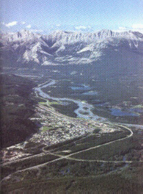
 ジャスパ-国立公園地図 ジャスパ-国立公園ジャスパ-国立公園は、エドモントンの西方370Km、カルガリ-の西北404Km、ヴァンク-バ-の東北805Kmにある.その中心が、ジャスパ-! 標高1060Mの高原の町.... バンフとは対照的にのんびりした山岳リゾ-ト 右写真が、ジャスパ-にあるインフォ-メンション・センタ- 7.6.午後4:30頃、 ジャスパ-の町に到着する. 一回り、町をまわって、直ちにエドモントンに向け出発! |
Jasper National Parkis the largest and most northerly of the four mountain parks. The landis rugged and diverse, with endless opportunities to discover its natural beauty. In addition to the attractions described below, there are over 1000 km of trails to explore. The Town of Jasper is the main service centre in the park. Jasper National Park is situated 370 km (192 mi) west of Edmonton, 404 km (256 mi)northwest of Calgary and 805 km (500 mi) northeast of Vancouver. Commercial airlines do service the major centres of Edmonton, Calgary and Vancouver. Both Vancouver and Edmonton have regular bus and train service to Jasper. There are tour buses which travel to and from Jasper via Banff. There are several car rental agencies located in the Jasper and Banff townsites.  Jasper Townsite Information Centre. |
Jasper TownsiteThe town ofJASPERis the administrative, residential and commercial heart of JASPER NATIONAL PARK which is the largest of the five CANADIAN NATIONAL PARKS which stretch for 500 miles (800 Km) along the eastern ranges of the spectacular Canadian Rockies. Jasper -- the park -- was named after a former fur trading post in the area called JasperHouse, which in turn was named after Jasper Hawse, who managed this post in the early1800s. The town had been known by settlers in the early 1900s as "Fitzhugh", but became"Jasper" when the park was established. |
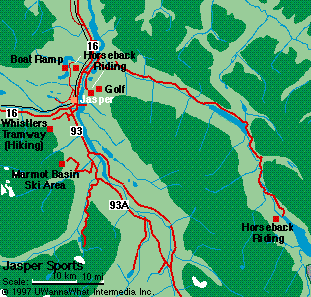
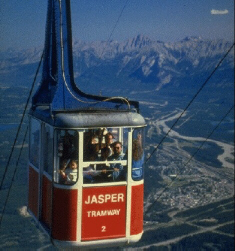
ジャスパ -の町が一望Whistlers Mountain.には、ゴンドラがついており.この山頂からは、ジャスパ-の町が一望できる.左の写真はジャスパ-をエドモントン方向に望む.町の側をアタバスカ川がエドモントン方向に流れる.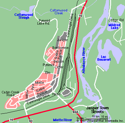 Jasper Townsite Map |
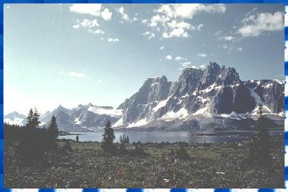 Tonquin Valley |
Tonquin ValleyA straight forward but fairly long approach leads toone of Canada's most magnificent views. Tonquin Valley will awe you. At an elevation of approximately 2000 metres (6500 Ft), and 33 kilometres southwest of Jasper, lies the beautiful Tonquin Valley and it's majestic Ramparts. There are three routes to travel into the Tonquin Valley. トンキンバリ-ジャスパ-33Kmに、標高2000mの素晴らしい景観を有するTonquin Valleyがある. |
Skyline TrailThis mountain region is accessible via a truly spectacular trail crossing beautiful alpine meadows and ascending over several passes. Renownd for its scenery and resident wildlife, this area is resident to Big Horn Sheep, Elk, Caribou, Mountain Goats,Marmots and many others. Alpine wild flowers are in full bloom by late July and into August. The highestpass on the Skyline trail is called the Notch. From here the full skyline is visible as the route follows a safe but exposed ridge. 飛行機によるカナディアン・ロッキ-・ツア-飛行機によるカナディアン・ロッキ-の定期観光ツア-が行われており、一段と迫力のある景観を楽しむことができる. |
 Skyline Trail |
 The Jasper Tramway 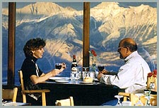 Restaurant 、upper terminal, |
The Jasper TRAMWAY-Whistlers Mountain-takes you to the top of nearby Whistlers Mountain. From this 8,600feet high vantage point you can see on a clear day (and we have an unbelievably large number of clear sunny days in Alberta) 50 miles to the west to Mount Robson which, at 12,970 feet, is the highest point in the Canadian Rockies. 絶景!ウイスラ-・マウンテンウイスラ-・マウンテンは、標高2469m、山頂までロ-プウェイがついており、展望台から見る景色は絶景!!!1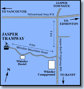 Jasper
Tramway Map Jasper
Tramway Map | ||||
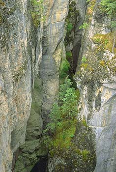
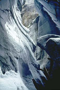
Maligne Canyon-Jasper National Park-Maligne River plunges 23 metres (75 feet) into a steep walled gorge of limestone bedrock. A self-guiding trail takes you over six different footbridges, providing spectacular views of thecanyon en route. A teahouse is located at the parking area. During the cold winter months, the river runs silent. Ice climbers tackle the frozen waterfalls and guided tours are avialable to take you into a world of frozen beauty. マリ-ン峡谷深さ55Mの峡谷が、マリ-ン川がアサバスカ川に注ぐ所にできて、カナディアン・ロッキ-の奇観!!峡谷の巾、数m!! |
|
 Maligne Lake |
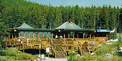
Maligne Lake-Mt Charlton and Mt. Unwin in the background.-Maligne Lake is the largest lake in Jasper National Park at 22 km in length (14 miles) and alsothe deepest at 97 metres (320 feet). Renowned for its scenery and fishing, the area also offers exceptional hiking opportunites. A concession provides cruises to the midpoint on the lake, the narrows, were lies world famous Spirit Island. Other services include boat rentals, trail riding, fish guiding and a restaurant. マリ-ン・レイク世界で二番目に大きい氷河湖!遊覧船によるボ-ト・クル-ズ、フィッシングが盛ん! 湖畔には、展望ロッジもあり、レストランも併設している. |
The Lodge overlooking Maligne Lakeis a spectacular place for a luncheon, a coffee break, afternoon tea or a cool drink. The choice of salads, home-styled sandwiches, home-made soups, stew and vegetarian chili remains the best in Jasper National Park. A vast assortment of fresh breads, tortes, cookies and pastries are baked daily in Maligne’s on-site bakery. The Dining Room is available for groups of 20 or more for an evening buffet. |
 The Lodge overlooking Maligne Lake |
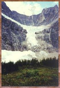 Mount Edith Cavell.& Angel Glacier |
Mount Edith Cavell.& Angel GlacierJasper National Park. Mount Edith Cavell. An impressive 11,000 foot peak, Mount Edith Cavell is famed for its Angel Glacier,Mount Edith Cavell Parking lot. From here, two short interpretive trails show the two sides to life in the alpine. One, thePath of the Glacier Trail, takes you through the debris left behind by the retreat of local glaciers. In its path, it has left mounds of glacial debris (called moraines), rocks scoured and scraped by the passing ice, and two remnant glaciers, the Angel and Cavell Glaciers. エンゼル氷河とMount Edith Cavell.Mount Edith Cavell.には、天使が羽目を広げたように見えAngel Glacierがあることで有名!!!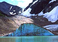 Mount Edith Cavell.& Angel Glacier |
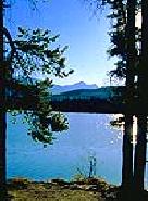
Pyramid Lake. This lake allows gasoline powered motors, and boats are available for rent at Pyramid Lake Bungalows.Cast a line for rainbow and lake trout along with Rocky Mountain Whitefish. In fact the Alberta record white sucker was taken in Pyramid Lake. During winter, a lighted skating rink is maintained on the lake surface. ピラミッド湖フィッシングの盛んな湖、Pyramid Lake Bungalowsも整備されている. |
 ramid
Lake ramid
Lake |
![]()
![]()
![]()
![]()