摴楬埬撪昞帵丂俙倳倰倢倎値倓亅俼俆侽亅Skarvheimen
-Hol -Oslo
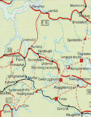
there is a small road by the railway from丂Haugastøl
to Finse, Hallingskeid, Myrdal and down to
Flåm. It is possible to cycle on this
road from July - September. Most of the road
is accessible in June, but there might be
big snowpiles between Finse and Hallingskeid
where you might have to carry your bicycle.
Motorists should note that the road Aurland-Lærdal
is closed all winter, and that the roads
Aurland-Hol and Hemsedal can be closed during
bad weather.Norway Bussekspress
Although "Skarvheimen" is
a newly
invented word, the area between Hardangervidda
and Jotunheimen has been used by mountaineers
for many years, and for travel and
hunting
even longer. The lack of a common name
has
without reason made the area less visited
than丂other mountain areas in central
South-Norway.
So the area should now be more attractive
than ever.丂Map |
埬撪昞帵偵偼偙傟偐傜搊傝偺摴嬝偑帵偝傟偰偄偨丏
偙偺偁偨傝偼丄俙倳倰倢倎値倓倱倓倎倢倕値偲偄偮偰丄壞偼僴僀僉儞僌僐亅僗搤偼僗僉亅偲側偮偰偄傞丏
僼傿儓儖僪傪忋傝愗傞偲丄忋偼暯傜側戜抧偑僣僘僋偙偲偑抧恾偐傜撉傒庢傟傞丏
Skarvheimen - Routes-R50-摴楬抧恾 |
俽倴倕倝値倗倎倰倓倱倐倧倲倛偺戜抧偵偼丄懡偔偺屛偑揰嵼偟偰偄偨丏
屛柺偼搥傝丄偦偺忋偵愥偑愊傕偮偰偄傞丄姦乆偲偟偨晽宨偑墑乆偲僼傿儓儖僪戜抧偺忋偵揥奐偟偰偄傞丏
懳徠揑偵嬻偼塤堦偮側偄惵乆偲偟偨嬻娫偑峀偑傝丄幵偺拞偱庴偗傞懢梲偺岝慄偼弸偔丄旂晢偑徟偑偝傟偰偄偔偺偑傢偐傞丏
幵偼傂偨偡傜丄屛斎増偄偵憱傞摴傪僆僗儘偵岦偐偭偰閩恑偝偣偰偄傞丏帪乆嶳彫壆僉儍價儞傪尒偐偗傞丏
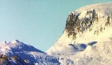
is derived from the many "Skarv"s in the area, the biggest are
Hallingskarvet and Reineskarvet. A Skarv is a long mountain, very steep
on the sides, but relatively flat on the top. Hallingskarvet is about 40
km long, and 2-3 km wide. It reaches up to 1900 meters altitude, whereas
the terrain around is mostly below 1500 meters. Reineskarvet further north
is also great, although not at the same magnitude.
|
僼傿儓儖僪傪搊偭偨強偵峀偑傞戝愥尨亅俼俆侽亅 |
俽倴倕倝値倗倎倰倓倱倐倧倲倛戝愥尨亅俼俆侽亅 |
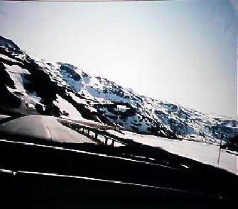
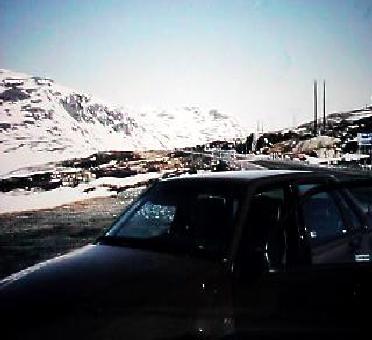
僼傿儓儖僪戜抧偺忋傪幵偼夣揔偵憱傞丏師乆偲弌偰偔傞戝愥尨傪摜攋偟丄搑拞幵傪巭傔偰媥宔傪偟偰偄傞偲偙傠丏
嬻婥偑偍偄偟偄両両両
搑拞丄俫倧倴倕倲嶳墇偊偰俫倧倢偵岦偐偆
俽倴倕倝値倗倎倰倓倱倐倧倲倛戝愥尨亅俼俆侽亅
is not only Skarvs. Both from east and west, long valleys cut into the
mountain area. The eastern valleys are long and fall slowly towards the
valleys of inner East-Norway. The valleys in the west on the other hand,
are steep. They fall directly down to the fjordarms of the Sognefjord.
Especially noted is the valley Aurlandsdalen. This very wild valley starts
as a wide valley in the mountains, but gets narrower and narrower as it
descends towards the fjord. The path in the last part of this valley, goes
in the middle of the mountainside to avoid the wild river. |
俫倧倢偺挰偼丄俼俆侽崋慄偲俼俈崋慄偺崌棳偡傞偲偙傠丄僼傿儓儖僪戜抧忋偺屛斎増偄偵奐偐傟偨偺偳偐側暤埻婥偺挰偱偁偭偨丏
弌敪抧儀儖僎儞傛傝丄俁侽俉俲倣偺抧揰偱偁傞丏
傑偨丄俙倳倰倢倎値倓偐傜僼傿儓儖僪戜抧墇偊傞偙偲丄侾俁俇俲倣偺抧揰偱偁傞丏揦偺柤慜偼丄俫倕倢倢倝値倗
俲倎倖倕倲倕倰倝倎
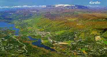
乭俫倧倢乭挰 HOL - GEILO
ungdomsskole ligger på Geilo i Hol kommune, Buskerud. Elevene kommer fra hele Hol kommune. Det er 140 elever og 21
lærere ved skolen. Geilo er ei fjellbygd ca. 800 m.o.h. Bygda ligger
i et naturområde med rike muligheter for turgåing både
sommer og vinter. Turisme er en viktig del av næringsgrunnlaget for
kommunen.
Andre bygder i Hol kommune er Dagali, Skurdalen,
Hol og Hovet.
KOMMUNAL INFORMASJON
舕
Gol
|
乭俫倧倢乭挰偺媔拑揦偱堦媥傒 |

